
Japanese平安京の都市設計と朱雀大路
Heian-kyō's City Plan and Suzaku-ōji
Other spellings and namesHeian-kyō (平安京) / Jōbō system (条坊制) / Suzaku Avenue (朱雀大路) / Rajōmon (羅城門) / Shijin sōō (四神相応)
In short
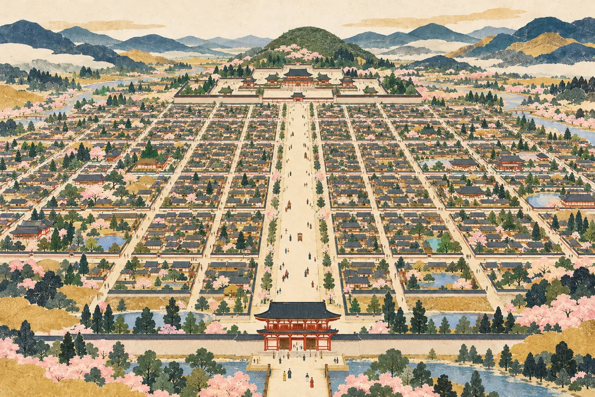
Suzaku-ōji (朱雀大路, Suzaku Avenue) was a great avenue about 84 meters wide that ran north–south through the center of Heian-kyō, roughly corresponding to present-day Senbon-dōri. Heian-kyō was built in 794 on the model of Chang'an in China; it was divided by Suzaku-ōji into the Sakyō (Left Capital) and Ukyō (Right Capital), and laid out in a checkerboard grid using the units jō, bō, ho, and chō. It was a capital where you could describe a location by numbers alone, as in "Sakyō Sanjō Shibō Nichō" (Left Capital, 3rd jō, 4th bō, 2nd chō).Key points in 30 seconds
朱雀大路 is read Suzaku-ōji (すざくおおじ); it was about 84 m wide
Suzaku-ōji roughly corresponds to present-day Senbon-dōri
Heian-kyō was built in 794 and measured about 4.5 km east–west and 5.2 km north–south
1 bō = 4 ho = 16 chō; one chō was about 120 m on each side
A new capital modeled on Chang'an
In 794, Emperor Kanmu moved the capital to Heian-kyō. This was the beginning of Kyoto's long role as the center of Japanese culture.
Heian-kyō was built in 794 with Chang'an, the capital of Tang China, as its model.
Heian-kyō was a rectangle measuring about 4.5 kilometers east–west and about 5.2 kilometers north–south.
Heian-kyō extended about 5.2 kilometers from north to south.
Suzaku-ōji and Rajōmon
Suzaku-ōji ran from the Daidairi (Greater Imperial Palace) south to Rajōmon, dividing Heian-kyō into the Sakyō (Left Capital) and the Ukyō (Right Capital).
Rajōmon stood at the southern end of Suzaku-ōji and served as the southern entrance to Heian-kyō.
Suzaku-ōji roughly corresponds to present-day Senbon-dōri.
The shift to the Left Capital, and the jōbō system
Because much of the Ukyō (Right Capital) was damp, people moved to the Sakyō (Left Capital), and the eastern side of Kyoto developed.
The size of a chō, and the four guardian deities
Excluding roads, one chō was a square about 120 meters on each side.
The Kamo River in the east was likened to the Azure Dragon (Seiryū), the San'indō road in the west to the White Tiger (Byakko), Mount Funaoka in the north to the Black Tortoise (Genbu), and Ogura Pond in the south to the Vermilion Bird (Suzaku).
One bō was divided into four ho, and each ho was further divided into four chō, so 1 bō = 4 ho = 16 chō.
Suzaku-ōji was about 84 meters wide and linked the Daidairi with Rajōmon.
Changes in the late 9th century added two gates to the Daidairi, which originally had 12, making 14.
Ogura Pond in the south was regarded as the Vermilion Bird, the Kamo River in the east as the Azure Dragon, the San'indō in the west as the White Tiger, and Mount Funaoka in the north as the Black Tortoise.
Rajōmon, never rebuilt
Rajōmon collapsed in a storm in July 980 and was never rebuilt.
How do you read "Sakyō Sanjō Shibō Nichō"?
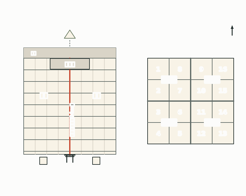
Heian-kyō was broadly divided by nine great avenues (ōji) running north–south and eleven running east–west: Ichijō through Kujō Ōji (First through Ninth Avenues), plus Tsuchimikado Ōji and Nakamikado Ōji. The east–west rows were called jō and the north–south columns bō, and the blocks about 550 meters (180 jō 丈, a unit of length) on each side enclosed by avenues were also called bō. The Sakyō and Ukyō each had nine jō and four bō, with a half-jō strip, the Hokuhenbō, added at the north.
The bō are counted from 1 to 4 starting nearest Suzaku-ōji—eastward in the Sakyō and westward in the Ukyō. Each bō was divided into 16 chō by lanes (kōji) about 12 meters wide, and the chō were numbered 1 to 16 in a zigzag (chidori) pattern from north to south, starting on the Suzaku-ōji side. In this way, a location could be indicated by numbers alone, as in "Sakyō Sanjō Shibō Nichō."
Heian-kyō's jōbō grid and the chō within one bō
Units of land division in Heian-kyō
| Unit | Size / breakdown |
|---|---|
| Bō (坊) | A block about 550 m (180 丈) on each side, enclosed by avenues. 4 ho = 16 chō |
| Ho (保) | A unit grouping 4 chō together |
| Chō (町) | A square about 120 m (40 丈) on each side, excluding roads |
| Henushi (戸主) | The smallest residential plot, made by dividing one chō into 32 under the shigyō hachimon (four rows, eight gates) system. 5 丈 north–south by 10 丈 east–west |
How were the capital's boundaries decided?
The extent of Heian-kyō is thought to have been decided by weighing several conditions, rather than by a standard as clear as those of Fujiwara-kyō or Heijō-kyō. Futagaoka limited it to the west, and the course of the Kamo River limited it to the east. Mount Funaoka in the north lies due north of Suzaku-ōji (present-day Senbon-dōri), and it is also thought to have served as the reference point for setting the capital's area.
On the other hand, there is also a theory that the reference was the Toba no Tsukurimichi, a road running in a straight line through Toba to the south. However, there is also a view that this road is better understood as the result of extending Suzaku-ōji southward, and that regarding Mount Funaoka as the reference point is more convincing. Mount Funaoka is a small hill about 112 meters high, designated a National Historic Site, with an ancient iwakura (sacred rock) at its summit.
The shape of the capital did not stay the same from beginning to end. The Sankaiki, a diary from the end of the Heian period, records that Tsuchimikado Ōji was originally called Ichijō Ōji, and that Ichijō Ōji was later moved about 200 meters north to enlarge the Daidairi. This change is dated roughly to the late 9th century, and the plans of Heian-kyō that have come down to us show the capital after the change.
Traces of Heian-kyō in today's Kyoto
The bō of Heian-kyō were given Chinese-style names modeled on the ward names of Chang'an and Luoyang. The bō names Dōda, Kyōgyō, Junpū, Annei, Sūjin, Tōka, and Kōtoku are still used as school district names in Kyoto City. The avenues and lanes, too, gradually acquired names such as Mibu, Ōmiya, Higashinotōin, Nishinotōin, Inokuma, Horikawa, Muromachi, Takatsuji, Ayanokōji, and Nishikikōji, which have been passed down to today's street names.
Within the capital, besides the Daidairi, were placed Shinsen-en, which occupied eight chō; the East and West Markets, twelve chō each; and Tō-ji and Sai-ji, four chō each. The plans (sashizu) of Heian-kyō are the oldest surviving plans of the capital; the one handed down in the Konoe family is held by the Yōmei Bunko in Ukyō Ward, and the one handed down in the Kujō family by the Tokyo National Museum. Both are Kamakura-period copies.
Mini quiz for this entry
Check what you've read with 3 multiple-choice questions.
Which of these events happened in 794?
Approximately how wide was Heian-kyo from east to west?
Which correctly describes one bo in Heian-kyo's grid?
Sources and verification
Content checked: October 11, 2026
Updated: October 11, 2026
References are in Japanese.