
Japanese鴨川・賀茂川・高野川の合流点
The Kamo River Confluence: 鴨川, 賀茂川, and the Takano River
Other spellings and namesKamogawa / Kamo River / Takano River / Demachiyanagi / Shirakawa / 賀茂川 / 高野川

In short
Kyoto's Kamo River (鴨川) meets the Takano River near Demachiyanagi. Upstream, it is also written 賀茂川 (also read Kamogawa), and its tributary the Shirakawa rises on Mount Hiei and flows through Gion.Key points in 30 seconds
It meets the Takano River at Demachiyanagi
Upstream it is sometimes written 賀茂川
The Shirakawa rises on Mount Hiei and flows into the Kamo River
The Kamo River as a symbol of Kyoto
The Kamo River has long been cherished as a symbol of Kyoto alongside Higashiyama.
Where the 賀茂川 and the Takano River meet
The Kamo River is commonly written 賀茂川 above its confluence with the Takano River and 鴨川 below it; both are read Kamogawa. Under the River Act, however, the official name of the entire river is 鴨川.
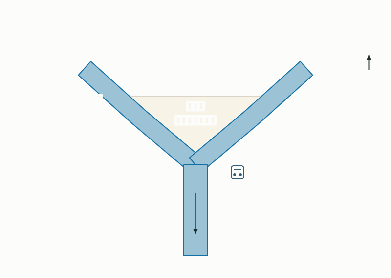
Near Demachiyanagi, the 賀茂川 from the west and the Takano River from the east meet in a Y shape, and downstream from there the river flows on as the 鴨川.
The Shirakawa, flowing through Gion
The Shirakawa rises on Mount Hiei, gathers water from Mount Nyoigatake as well, passes through Gion, and flows into the Kamo River.
Where does the Kamo River come from, and where does it go?
The Kamo River rises near Mount Sajikigatake, flows north to south through Kyoto City for about 27 km, and joins the Katsura River. Under the River Act, the entire stretch, from its starting point in Kumogahata to its confluence with the Katsura River, is the 鴨川.
A river's left and right banks are determined as seen when facing downstream, so for the southward-flowing Kamo and Takano rivers, the west side is the right bank and the east side is the left bank. At the Demachiyanagi confluence, the 賀茂川 comes in from the west and the Takano River from the east, and from the base of the Y the river flows south as the 鴨川.
The Demachiyanagi confluence and the river names
The great flood of 1935 and today's riverbanks
Today's calm Kamo River took shape after a major flood. In June 1935 (Shōwa 10), heavy rain caused the Kamo River to overflow, killing or injuring 12 people, washing away 137 houses, and flooding 24,173 buildings above or below floor level; bridges were swept away too.
Fundamental improvement works followed from 1936 to 1947, and even in the largest postwar flood, in August 1959, the Kamo River is said to have caused no flood damage. After the works, the riverbanks were developed as green spaces with lawns and sports areas. Black-headed gulls, a familiar sight on the Kamo River in winter, were first recorded arriving in January 1974.
Riverbank rules: the Kyoto Prefecture Kamo River Ordinance
The Kamo River's banks have rules under the Kyoto Prefecture Kamo River Ordinance. The ordinance was promulgated on July 10, 2007, and its regulatory provisions took effect on April 1, 2008. It prohibits things such as driving cars and other vehicles onto the riverbanks, abandoning bicycles, setting off aerial fireworks, barbecues, and graffiti. Electric kick scooters are classified as motorized bicycles and may not be ridden onto the riverbanks (as of October 2026).
On the Kamo River it's yuka; in Kibune it's toko
A summer highlight of the Kamo River is the nōryō-yuka, or riverside dining platforms. Between Nijō and Gojō on the west bank, about 90 restaurants, ryōtei, and cafés build platforms (yuka) over the riverbank, a practice said to date back to the Momoyama period. The 2026 platform season ran from May 1 to October 15, with operating periods and lunch service varying by establishment.
The name differs too. Around Shijō on the Kamo River, they are generally called nōryō-yuka (納涼床, read yuka), while near the Kibune River and the Kiyotaki River in Takao they are called kawadoko (川床, read doko). Even for the same kind of place to cool off above a river, the word changes from place to place.
Mini quiz for this entry
Check what you've read with 3 multiple-choice questions.
The Kamo River is described as a Kyoto symbol alongside which place?
Which spelling is sometimes used for the Kamo River above its confluence with the Takano River?
Where are the Kamo and Takano rivers known for meeting?
Sources and verification
Content checked: October 11, 2026
Updated: October 11, 2026
References are in Japanese.