
Japanese京の七口(きょうのななくち)
Kyō no Nanakuchi (Seven Entrances to Kyoto)
Other spellings and namesNanakuchi / Shichikuchi / Seven Entrances of Kyoto / Kuramaguchi / Tanbaguchi / Awataguchi
In short
Kyō no Nanakuchi ("the Seven Entrances to Kyoto") is a collective name for the points where the highways linking Kyoto with other regions entered the city. They are said to have become known as the openings in the Odoi, the earthen wall Toyotomi Hideyoshi built in 1591, but the number and the names of the entrances differ by period and by source, and "seven" does not mean exactly seven.Key points in 30 seconds
A collective name for the entrances of highways leading into Kyoto; also read Shichikuchi
One count lists seven: Nagasaka-guchi, Kuramaguchi, Ōhara-guchi, Awataguchi, Fushimi-guchi, Toba-guchi, and Tanbaguchi
There were about 10 entrances at first, said to have grown to 40 by the early Edo period
Names such as Kuramaguchi, Tanbaguchi, and Awataguchi survive as place names and station names
Kuchi means a highway entrance
Kuchi (口, literally "mouth") means the entry or exit point of a highway leading to Kyoto. When Toyotomi Hideyoshi built the Odoi, openings were made in the earthen wall, and these are said to have become known as the Kyō no Nanakuchi. The Kyō no Nanakuchi is a collective name for the entrances of the main highways linking Kyoto with the rest of the country, and the number of entrances differs by period. The name also has two readings: Nanakuchi (ななくち) and Shichikuchi (しちくち).
Another view holds that when Heian-kyō was built and the main roads came to lead to Kyoto, the Kyoto ends of those highways were called the Kyō no Nanakuchi. From them, highways such as the Kurama Kaidō, Wakasa Kaidō, Fushimi Kaidō, San'in Kaidō, Atago Kaidō, and Toba Kaidō stretched out to various regions.
The link with the Odoi
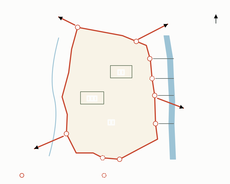
The Odoi was an earthen rampart that Hideyoshi built in 1591 as part of his reshaping of the city. It served both as a defense against outside enemies and as a levee against flooding of the Kamo River. The Nanakuchi are said to have been set at key points along it as the entrances between Rakuchū, inside the rampart, and Rakugai, outside it.
The entrances represented by the Kyō no Nanakuchi numbered only about 10 at first, but are said to have increased to 40 by the early Edo period. In the Edo period, once new levees were built along the Kamo River, the eastern part of the rampart was gradually torn down, and most of it was lost in modern times.
Approximate locations of the Odoi and the Kyō no Nanakuchi
"Seven," yet the numbers don't add up?
Which entrances count as the Nanakuchi differs from source to source. One count lists seven: Nagasaka-guchi, Kuramaguchi, Ōhara-guchi, Awataguchi, Fushimi-guchi, Toba-guchi, and Tanbaguchi. Another explanation lists Kuramaguchi, Ōhara-guchi, Kōjinguchi, Awataguchi, Fushimi-guchi, Tōji-guchi, Tanbaguchi, Nagasaka-guchi, and others, and says that "about 10" entrances were generally called the Nanakuchi as a group.
Comparing six documents, five—Kuramaguchi, Ōhara-guchi, Awataguchi, Fushimi-guchi, and Nagasaka-guchi—appear in nearly all of them, while the rest, such as Shirakawa-guchi, Takeda-guchi, Toba-guchi, Tōji-guchi, Nishi-Shichijō-guchi, Tanbaguchi, and Kōjinguchi, vary from source to source. The Nanakuchi are also said to have been so called only "popularly," so it is natural to think of "seven" not as an exact number but as a way of referring to Kyoto's entrances as a whole.
- Example of a count listing seven: Nagasaka-guchi, Kuramaguchi, Ōhara-guchi, Awataguchi, Fushimi-guchi, Toba-guchi, Tanbaguchi
- Entrances added in some sources: Kōjinguchi, Tōji-guchi, Takeda-guchi, Shirakawa-guchi, Nishi-Shichijō-guchi, and others
Where did each entrance lead?
Kuramaguchi, at Izumoji in Kita Ward, was the starting point of the Kurama Kaidō, which led to Kurama by way of Kamigamo, Hataeda, Ichihara, and Futase; a checkpoint was set up there in the Muromachi period. Awataguchi in Higashiyama Ward became a key transport point after the capital moved to Heian-kyō, as the entrance to Kyoto from the three routes of the Tōkai, Tōsan, and Hokuriku circuits, and it was also called Sanjō-guchi or Ōtsu-guchi.
The road from Nagasaka-guchi in the north over Kyōmi Pass toward Wakasa and Tanba was an important route, and there was also a checkpoint on it in the Muromachi period. Tanbaguchi in the west was the entrance of the old San'in Kaidō linking Tanba and Kyoto, and its name is also used for a station.
Main entrances, the roads they led to, and clues today
| Entrance | Road / direction | Clues today |
|---|---|---|
| Nagasaka-guchi (長坂口) | Over Kyōmi Pass toward Wakasa and Tanba | The road to Kyōmi Pass (elevation 446 m) |
| Kuramaguchi (鞍馬口), also Izumoji-guchi | Kurama Kaidō (to Kurama via Kamigamo and Ichihara) | Stone marker "Izumoji Kuramaguchi" (1970) at the west end of Izumoji Bridge, Kita Ward |
| Ōhara-guchi (大原口) | Toward Ōhara, as the name indicates | Signpost "Ōhara-guchi" (1868) at the northeast corner of Imadegawa-dōri and Teramachi, Kamigyō Ward |
| Kōjinguchi (荒神口) | Counted among the Nanakuchi in some sources | Survives as a place name |
| Awataguchi (粟田口), also Sanjō-guchi / Ōtsu-guchi | The three routes of the Tōkai, Tōsan, and Hokuriku circuits | Stone marker (1970) in front of Awata Elementary School, Higashiyama Ward; place name along Sanjō-dōri east of Shirakawa Bridge |
| Fushimi-guchi (伏見口) | Toward Fushimi, as the name indicates | — |
| Toba-guchi (鳥羽口) / Tōji-guchi (東寺口) | Toward Toba and Tōji in the south, as the names indicate | Sources differ on which one is counted |
| Tanbaguchi (丹波口) | Old San'in Kaidō (toward Tanba) | Tambaguchi Station on the JR Sagano Line |
Where can you see them today?
In 1970 (Shōwa 45), Kyoto City erected stone markers showing the locations of Awataguchi and Kuramaguchi. The Awataguchi marker stands in front of Awata Elementary School, on Jingū-michi just south of Sanjō in Higashiyama Ward, and the "Izumoji Kuramaguchi" marker stands at the west end of Izumoji Bridge in Kita Ward. At the northeast corner of Imadegawa-dōri and Teramachi, an "Ōhara-guchi" signpost erected in 1868 (Keiō 4) by Sumaya Ihei and 18 others still remains, engraved with the distances to places such as Shimogamo, Mount Hiei, Yoshida, and Kurodani.
Nearby, at the west end of Demachi Bridge, stands a "Saba Kaidō-guchi" stone marker erected in 2001 by the Demachi shopping street association, engraved "従是洛中" ("from here, Rakuchū"). The Saba Kaidō ("Mackerel Road") is the Wakasa Kaidō, which runs north from here along the Takano River and reaches Obama by way of Yase, Ōhara, and Kutsuki; the marker shows its starting point.
As for the Odoi itself, eight surviving sections in the city were designated historic sites in 1930, and one more within the grounds of Kitano Tenmangū was added in 1965, so nine sections are now national historic sites. Tracing the place names left by the entrances together with the remains of the rampart in Kita Ward and elsewhere brings the outline of old Rakuchū into view.
A common misunderstanding
People often think the Nanakuchi were exactly seven entrances set up by Hideyoshi, but as we have seen, both the number and the names differ by source. There are also said to have been checkpoints in the Muromachi period at Kuramaguchi and on the road over Kyōmi Pass from Nagasaka-guchi, and Awataguchi had been an entrance to Kyoto ever since the capital moved to Heian-kyō. The name Nanakuchi is said to have become known only after the Odoi was built, but the entrances themselves can be said to have been places where people and goods came and went even before the Odoi.
Mini quiz for this entry
Check what you've read with 2 multiple-choice questions.
In the names of the Kyō no Nanakuchi (Seven Entrances to Kyoto), such as Awataguchi, Kuramaguchi, and Tanbaguchi, what does kuchi (口) refer to?
Which of the Kyō no Nanakuchi was also called Sanjō-guchi or Ōtsu-guchi?
Sources and verification
Content checked: October 11, 2026
Updated: October 11, 2026
References are in Japanese.
- 京都府立図書館「『京の七口、昔の道と旅』ミニコーナーのご案内」
- 国立国会図書館 レファレンス協同データベース(京都市図書館)「御土居(おどい)と京の七口(または十口など)の位置が一緒に掲載された図を古地図以外で見たい。」
- 京都市「史跡 御土居」
- 京都市「都市史18 聚楽第と御土居」
- 京都市・京都市埋蔵文化財研究所「京都歴史散策マップ8 御土居跡」
- 京都市「京都市歴史的風致維持向上計画」第2章(街道に見る歴史的風致)
- 京都市「京都のいしぶみデータベース KI023 出雲路鞍馬口」
- 京都市「京都のいしぶみデータベース HI016 粟田口」
- 京都市「京都のいしぶみデータベース KA098 大原口【道標】」
- 京都市「京都のいしぶみデータベース KA019 鯖街道口」
- 京都市「京都のいしぶみデータベース KI060 御土居」
- 京都市観光協会 京都観光Navi「京見峠」
- 京都市観光協会 京都観光Navi「粟田口」
- JR西日本「沿線点描【山陰本線(嵯峨野線)】京都駅~園部」(Blue Signal 2018年1月号)