
Japanese両側町(りょうがわちょう)
Ryogawacho
Other spellings and namesRyōgawachō / Two-sided town / Town across the street / 両側町
In short
A ryōgawachō (両側町, "two-sided town") is a Kyoto town form in which the houses facing each other across a single street make up one town. Its defining feature is that the community is bound together around the street, not around the inside of a block, and from the medieval period onward it became the basic unit of self-government in Kyoto's towns.Key points in 30 seconds
Both sides of a street form one town
A town's boundary lies not on the street but behind the rows of houses
From the medieval period, it became the basic unit of self-government in Kyoto
It led to the chōgumi, the bangumi elementary schools, and the float-owning towns of the Gion Festival
The Street Runs Through the Middle of the Town
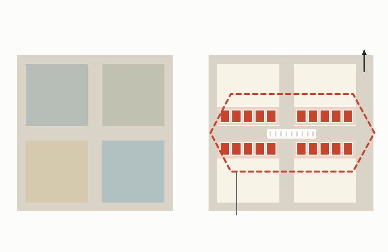
On modern maps, we tend to think of a block surrounded by roads as one unit. In a ryōgawachō, it is the opposite: the houses facing each other across a street form one town. The street was not a boundary but a shared space where neighbors saw each other every day.
So the boundary of a town runs not along the street but behind the rows of houses facing it—that is, through the inside of the block. Ryōgawachō formed a "tortoise-shell" shape straddling the street, and several such towns gathered to form an oya-machi (parent town).
Block-based units vs. the ryōgawachō
From Nimenmachi and Shimenmachi to Ryōgawachō
In Heian-kyō's original plan, each square block was one chō, and the nimenmachi ("two-sided block town"), with houses lining only its east and west sides, was envisioned. House entrances were also limited to either the east or the west side.
As the street became the center of daily life, this changed into the shimenmachi ("four-sided block town"), with houses on all four sides of the block, and then the shichōmachi ("four-chō town"), in which each of the four sides became independent as a chō. In times of war, for reasons such as ease of defense, two chō facing each other across a street joined to form a new town. This is the ryōgawachō.
From nimenmachi to ryōgawachō
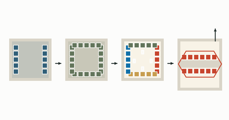
How town forms changed
| Stage | How houses were arranged | Unit of the town |
|---|---|---|
| Nimenmachi (二面町) | Houses only on the east and west sides of a square block | The block (one chō) |
| Shimenmachi (四面町) | Houses on all four sides of the block | The block (one chō) |
| Shichōmachi (四丁町) | Each of the four sides is independent | One side of a block (a chō) |
| Ryōgawachō (両側町) | Two chō facing each other across a street join together | A town centered on the street |
After the Ōnin War, Towns and Chōgumi Take on Self-Government
The Ōnin War shrank the urban area into two parts, Kamigyō and Shimogyō, but the towns built afterward were made up of the houses on both sides of a street. To protect their lives, Kyoto's residents expanded their self-governing organizations, and in the mid-16th century they formed chōgumi, federations of towns. The sōchō (united towns) of Shimogyō revived the Gion Festival, which had been suspended by the Ōnin War.
At that time, the urban area was concentrated into two parts: Kami-no-Kyō, running from the merchant town that developed west of the imperial palace to Nishijin, and Shimo-no-Kyō, a merchant town centered on the hoko (float) towns of the Gion Festival. Areas also arose where people of the same trade lived together, such as weavers and fan makers, and such groups of tradespeople supported Kyoto's industries.
In central Kyoto, from the medieval period onward, the ryōgawachō became the basic unit of self-government. In the Edo period, towns set rules covering the buying, selling, and leasing of land, residents' occupations, and even the outward appearance of townhouses, and towns and chōgumi became the foundation of both daily life and the townscape.
Carried On Through Hideyoshi's Redivision of the City
In 1590 (Tenshō 18), Toyotomi Hideyoshi ran a north–south lane through the middle of the square blocks, dividing each into two long, narrow rectangular blocks. The vacant land that had remained in the middle of the blocks was developed, and land came to be used more efficiently. Around the same time, temples scattered around the city were gathered into Teramachi and Teranouchi.
Even with more streets, the basic form of the town did not change. Even after the so-called Tenshō land division, in which Hideyoshi added these lanes, the basic form of the ryōgawachō has been carried on to the present day.
Where Can You See It Today?
In the early Meiji era, the chōgumi were reorganized into bangumi, and an elementary school was built for each bangumi. Sixty-four bangumi elementary schools opened in 1869 (Meiji 2). The self-governing organizations of the pre-modern period, by way of the bangumi and gakku (school districts), lead to today's resident-led community development.
The idea of the ryōgawachō also lives on in city planning. In December 2004, Kyoto City expanded the city center's mixed residential and commercial districts, aiming for harmonious townscapes in the ryōgawachō formed together by towns facing each other across a street.
Neighborhood-based events such as the float-owning towns of the Gion Festival and Jizō-bon show the ryōgawachō clearly. In addresses, too, a defining feature of the ryōgawachō is that houses across the street share the same town name. When you walk around town, try noticing whether the town-name signs on this side of the street and the other side are the same.
Mini quiz for this entry
Check what you've read with 2 multiple-choice questions.
What does Kyoto's ryōgawachō town pattern describe?
What town form, with houses lining only the east and west sides of a square block, was envisioned in Heian-kyō's original plan?
Sources and verification
Content checked: October 11, 2026
Updated: October 11, 2026
References are in Japanese.